
In September, I hike with the three friends in the Ragtag Daily Prompt photograph. I have not really backpacked into back country in years. The last time I carried the pack was in Italy with my daughter, a few years ago. She wanted to plan the trip as we went and stay in hostels. We did.
We hike in the first day, up switchbacks from the parking lot at about 3200 feet, to a pass at 5400 feet, over and down to a campsite. The sites for cooking are separate from the sleeping sites and there are serious big metal bear boxes. We are to put everything in them, including the deet and toothpaste and anything that could possibly interest a bear.
We pack day packs the second day and climb back up to the pass. We peel off there to the trail to Sahalie Glacier. After being on oxygen at sea level for a year and a half, I am beyond delighted that I can actually do this. We go up and up and the trail gets worse and worse, until it is rather nasty scree. Two other people coming down say it is even worse, slippery, unstable, if we go on.
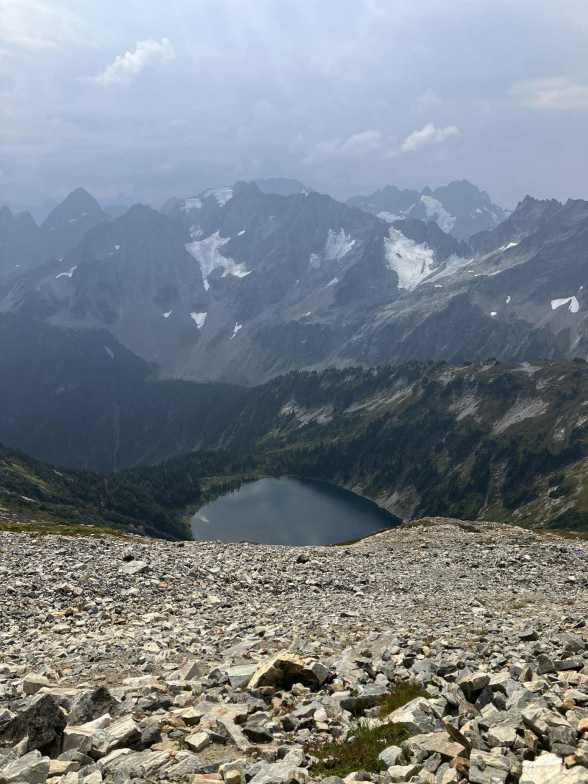
So, like sensible people, we stop for lunch. The slope is very steep and we each find a place to perch. Lunch tastes good. Then the other three want to go on. I don’t. I want a nap. They go on, I find a slab and the view from it is the photograph: down, down, down to the lake far below.
They will get me on the way back down.
And I do go to sleep. It’s all that night time call I’ve taken over years and years. I can sleep practically anywhere, including in a noisy casino in the past. I tuck up against the rock and the sun is almost warm.
I wake up. Two other people have come by. My inner clock thinks my people should have come by. Do I wait? Do I stay? There are more ominous clouds building up and this will be much more slick and dangerous if it starts raining. And we are exposed, for lightening.
Then I see a hat, on a curve of trail below me, moving. I swear it’s one of my party. But how did they go by without seeing me or waking me. THEY ARE DITCHING ME ON THE MOUNTAIN. No, that is ridiculous. Hmm. She is not with either of the guys. I debate for a minute, shout and then grab my things and head down.
I catch her. Once they left me, there really was not a clear trail. There were multiple sort of trails. And it was tricky. They separated a bit. She lost track of the other two and then picked the least difficult way down, which seemed to be a trail. It was NOT the trail that went by me, but she didn’t know that.
We found one of the guys below us, waiting. The last came down a bit later. None of them had come on the “right” trail by me. We headed down and stopped to put on rain gear. It rained lots! We were also above the tree line, but also I would say that we were above the marmot line. We saw eight hoary marmots marmoting around on our way down. They did not seem deterred by rain at all.
So that is how I was left in the scree to dream. I would have returned by the time it started raining anyhow, and the trail was good once we got past the scree. Not all the way to the lake in the photograph, the trail ran along a ridge that is not in the picture and wound down near the lake.
For the Ragtag Daily Prompt: scree.


You must be logged in to post a comment.